
SHADOW RESEARCH, Inc


© Shadow Research, Inc 1990 - 2021
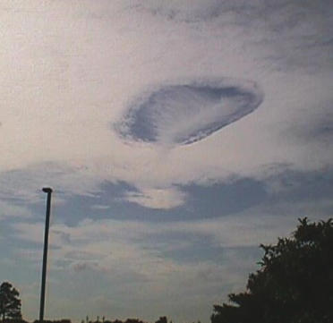
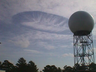
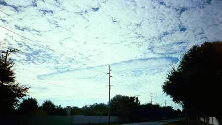
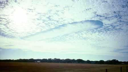
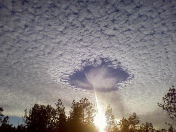
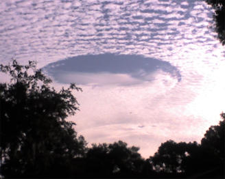
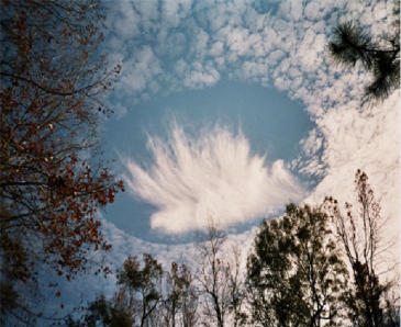
Hole-punch clouds over Melbourne November 12, 2000
Photos courtesy of National Weather Service, Melbourne. Photographers: Matt Bragaw, Peter Blottman. (See story below)
Ice crystals and the influence of the jet stream helped produce this dramatic scene on Thursday, Nov. 9 over the National Weather Service office in Melbourne.
Meteorologists call this formation "hole-punch" clouds.
Ice crystals, jet stream winds combine for rare display
By David Larimer
FLORIDA TODAY weather columnist
A unusual cloud formation appeared in skies over the Space Coast on Thursday caused by ice crystals and enhanced by the jet stream.
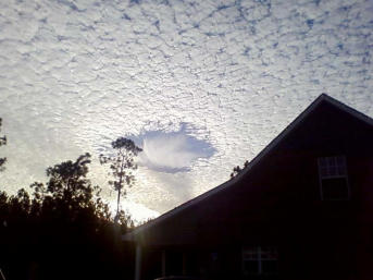
There is no scientific term for the cloud display you see above. The National Weather Service calls the formation "hole-punch" clouds because of the oval-shaped
opening.
The image was captured by meteorologists Matt Bragaw and Peter Blottman at the weather service office in Melbourne on Thursday morning.
The display is rare but has occurred in Melbourne skies in years past. In 1993, the weather service's Dennis Decker photographed a similar display. His dramatic
photo was published in a national weather magazine.
Randy Lascody, a senior meteorologist at the weather service office, explained the conditions that led to the striking formation:
"The atmosphere on Thursday was very dry from about 5000 to 28,000 feet. There was a rather extensive deck of cirrocumulus (mixture of 'super cooled' water
droplets and ice crystals) invading the sky associated with strong westerly jet stream winds.
"However, the 'hole-punch' features were aligned north/south. This suggests that there was some sort of 'wave' in the atmosphere that was causing rising/sinking
air couplets.
"This would cause ice crystals in the descending portion of the wave to fall into the super cooled (liquid) cloud layer. When this occurs, the ice crystals grow (at the
expense of the liquid droplets). Therefore, a hole opened in the deck of cirrocumulus.
"This process is similar to the principle used in cloud seeding to make cloud particles larger and produce precipitation. In this case, the precipitation aloft
(meteorological term is 'virga') descended into the dry air below 28,000 feet and evaporated (actually, the proper term for this process is 'sublimated').
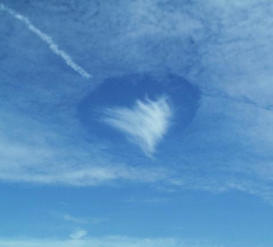
"The virga is evident in a few of the pictures descending from the center of the hole in the clouds. This resulted in a cone-shaped cloud high in the atmosphere that
I'm sure a few people thought was a funnel cloud."
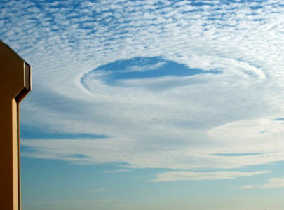
Hole Punch 2 Rohnert Park, California
This was sent to Art Bell at www.artbell.comHole Punch Cloud #-2
Sonya from Rohnert Park, California (S3CHURCH@aol.com) sends us:
I was at my daughters school function today and took this picture of a cloud formation behind us. I took meteorology in college and have never seen anything like
this before. I was going to e-mail it to my professor to see if he could explain it to me.
My husband seems to think that an object moved very quickly through the clouds and created a shockwave. You can see a contrail to the formation, the cone at the
bottom follows the trajectory then disappears. There were other contrails in the area. At the time I didn't think anything of it. Seems like I should have taken more
pictures! Meteor? Satellite? UFO?
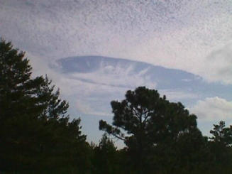
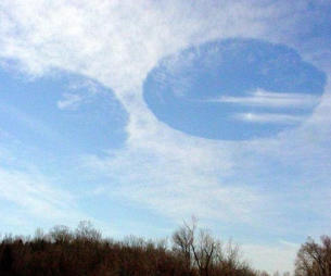
Hole Punch Clouds 3 Gallatin, TN.
Hole Punch - Circle in Clouds - Tennessee -
From the Coast to Coast Website (Artbell)
This photo (see full image below) was taken from my backyard between 10:00AM and 10:15AM 3/4/2003 with a Kodak Digital Camera. The circles appear to be in
the direction of Nashville TN which is about 32 miles south west of my home in Gallatin, TN.
I sent them to a local television station meteorologist. He said he had 2 theories. He said it could have been what the weather people call a thermal inversion,
Which means warm air rising in a circular motion much like a tornado only in reverse.
He also said the AMS (American Meteorological Society) mentioned in the AMS report, there are experiments with rain prevention being used by the U S Air Force
that have been known to cause this. He featured it on last night's weather report on the local Fox News channel.
--Wayne Carter
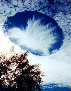
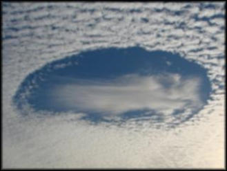
Hole Punch Cloud 3 over Mobile, Alabama, in the US, has left scientists puzzled. -
Local resident Joel Knain said as he took pictures: "I immediately realized that I was seeing something unique."
Meteorological experts believe the hole formed when ice-crystals from a passing plane fell through the cloud, causing the water droplets in it to evaporate.
Experts say the process involved is related to that of cloud seeding, which is used to make rain over crop fields.
Stuck inside of Mobile
The unusual phenomenon was observed on 11 December last year.
"I ran inside to get my camera and shot-off 10-12 frames to capture the scene," Joel told BBC News Online.
"I would guess that we stood there for 10-15 minutes just staring in amazement."
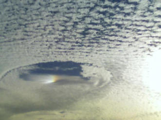
Strictly speaking there is no scientific term for the apparition, and what exactly it is has been the subject of much meteorological speculation.
One hypothesis is that the hole is made by falling ice-crystals that could have come from the exhaust of a passing aircraft.
It is possible the air was at just the right temperature and with just the right moisture content so that the falling crystals could absorb water from the air and grow.
The moisture removed from the air could have increased the evaporation of the cloud's water droplets, which then disappeared to produce the dramatic hole.
The wispy clouds seen below the hole may be heavier ice-crystals that have fallen from the hole, evaporating (the correct term is subliming) before they reach the
ground.
Image copyright Joel Knain
NEW Pictures of Hole Punch Clouds.
The following photos where posted on the Coast to Coast Website in December 2007.
TAMPA FLORIDA, HOLE PUCH CLOUDS - NOVEMBER 24, 2008
Source: Kristi Mcneill
http://www.abcactionnews.com/mostpopular/story.aspx?content_id=6553634b-a89b-4ca3-8d93-2757972c302f
TAMPA BAY, FL -- Many Bay area residents found themselves gazing upward at a very strange-looking cloud formation Monday morning. Several people who were
wondering what it was snapped some photos and emailed them to ABCActionNews.com.
According to a member of the ABC Action News Weather department, what they saw over the Clearwater area was something called a 'hole punch cloud.'
What is it? And what causes the phenomenon?
-----
Pictures by: Ron Snyder and Terry Dyar
Source: http://www.tampabays10.com/news/local/story.aspx?storyid=94719&catid=8
10Connects' viewers sent in some great pictures of a beautiful cloud phenomena you'll see every so often but certainly not on a frequent basis. The cloud
formation you see is known as hole punch clouds.
Morning data showcases a layer of high level moisture between 27,000 - 32,000 feet at a temperature of -25C to -30C. Upper level westerly winds managed to bring
this narrow ribbon of clouds into the bay area and they're cirrocumulus clouds. The composition of these clouds are ice crystals with super cooled droplets (liquid
water below freezing).
Super cooled droplets can freeze instantaneously when agitated (jet contrails for example) and are well known for their ability to freeze on contact in freezing rain
situations in northern parts of the country. In this case, something happened to trigger the process and the ice crystals grew larger at the expense of the super
cooled droplets. Evaporation also occurs around the droplets as the process unfolds and this in effect created the circular hole you see. Notice the batch of ice
crystals in the center that was a result of this process of the ice and super cooled droplets coexisting. Great pictures from Ron Snyder and Terry Dyar!!! Thank you
for sharing.
‘
Hole Punch Cloud Over Tampa, Florida - November 2008
By NEIL JOHNSON | The Tampa Tribune
November 25, 2008
The odd cloud formation seen around the Tampa Bay area on Monday morning initially caused some head scratching around here, but it turns out to have been a
rare formation but one documented before.
Meteorologists call it a "hole-punch cloud", a nontechnical but accurate name for the formation that looks like a hole was punched in a layer of clouds. St. Pete
Beach resident Gwen Swinburne was kind enough to send us a photo, and observant reader Rex Chivers wrote to say he saw two about 8 a.m. Monday, one near
Tampa, the other toward Pinellas and likely the one Swinburne photographed.
Apparently, a number of conditions can cause the formation.
On Tuesday, there was a layer of clouds high enough to be mostly ice crystals instead of simply condensed water. The air was highly stable, so the clouds were fairly
uniform. A pocket of cold air, which sinks toward the ground, "punched" the hole in the clouds and created the circular opening. That's what the meteorologists at
News Channel 8 say.
Sometimes rising air can cause the same effect.
These cloud formations have been observed before but are rare enough to catch the attention of the weather service.
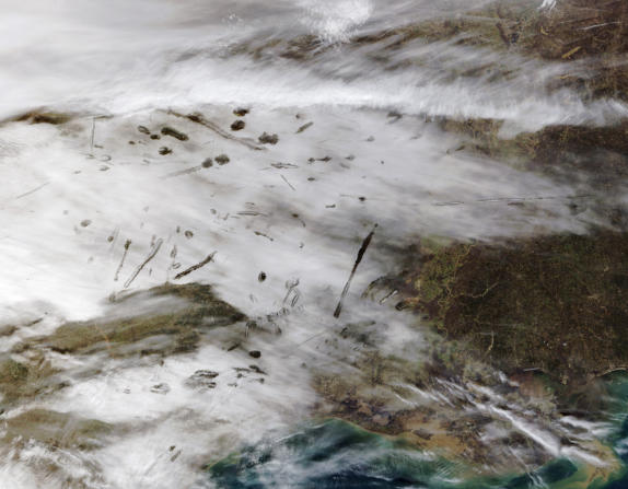
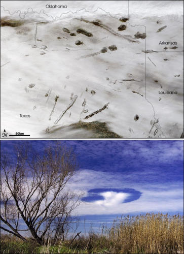
Hole Punch Clouds With Satellite Overhead - Acadiana, Louisiana - January 29, 2007
The North Platte Bulletin - Published 12/10/2008
Copyright © 2008 northplattebulletin.com - All rights reserved.
Flatrock Publishing, Inc. - 1300 E 4th St., Suite F - North Platte, NE 69101
On January 29, 2007, inhabitants of Acadiana, the Cajun heartland in southern Louisiana, saw unusual looking cloud formations. These “hole punch” clouds were
just as apparent from above as they were from below. This pair of images shows the hole-punch clouds captured by the Moderate Resolution Imaging
Spectroradiometer (MODIS) on NASA’s Terra satellite (top) and from the ground (bottom). The MODIS image shows a number of round holes in a blanket of cloud
cover over Oklahoma, Arkansas, Louisiana, and Texas. A few of the “holes” are elongated, with what appear to be smaller clouds inside them.
This strange phenomenon resulted from a combination of cold temperatures, air traffic, and perhaps unusual atmospheric stability. The cloud blanket on January
29 consisted of supercooled clouds. Supercooled clouds contain water droplets that remain liquid even though the temperature is well below freezing, and such
clouds are not unusual. According to the Cooperative Institute for Meteorological Satellite Studies (CIMSS) Satellite Blog, cloud-top temperatures ranged from 20 to
35 degrees Celsius. As aircraft from the Dallas-Fort Worth airport passed through these clouds, tiny particles in the exhaust came into contact with the supercooled
water droplets, which froze instantly. The larger ice crystals fell out of the cloud deck, leaving behind the “holes,” while the tiniest ice particles in the center
remained aloft.
The people on the ground watching the show these clouds made didn’t have to worry about getting wet or being showered with ice. When the general atmospheric
conditions aren’t favorable for rain, the falling ice crystals sublimate—change state directly from a solid to a gas—as they pass through warmer layers of the
atmosphere.
NASA image by Jeff Schmaltz, MODIS Rapid Response Team, Goddard Space Flight Center. Photograph © 2007 yesitspuzzling. Thanks to J. Marshall Shepherd,
University of Georgia, for image interpretation.
Hole Punch Over Alabama, USA
July 22, 2010


Hole Punch Clouds


